

Coastal towns experience a certain kind of dread when meteorologists begin to use the term “rapid intensification.” It is not the same as the gradual escalation of a normal storm warning. It indicates that the window is closing, the numbers are rising quickly, and there is less room for error. That’s precisely where the Gulf Coast is at the moment, watching Tropical Storm Isaias intensify hourly as it churns through waters that are the warmest on record.
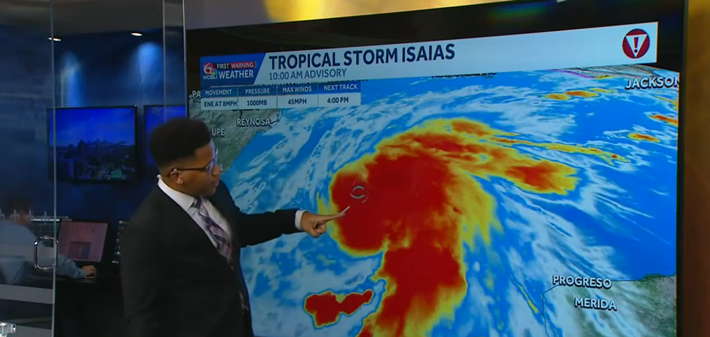
The ninth named storm of the 2026 Atlantic season, Isaias, developed Wednesday morning in the warm waters off eastern Mexico. This is unusual not only because of the timing but also because of the context. For the first time in thirty-two years, September concluded without a single hurricane. Throughout the season, storm activity had been subtly suppressed by a powerful El Niño. Then October came, and with it, Isaias.
| Detail | Information |
|---|---|
| Storm Name | Hurricane Isaias (2026) |
| Storm Type at Formation | Tropical Depression Nine / Tropical Storm |
| Formation Date | Wednesday, October 7, 2026 |
| Formation Location | Bay of Campeche, southern Gulf of Mexico |
| Season Rank | 9th named storm of the 2026 Atlantic hurricane season |
| Forecast Peak Intensity | Category 2 hurricane (winds near 110 mph) |
| Sustained Winds (as of Oct. 8) | 65 mph |
| Movement Speed | ~8 mph east-northeast |
| Expected Landfall Timing | Late Friday or early Saturday (Oct. 10–11, 2026) |
| Expected Landfall Zone | Between Gulfport, Mississippi and Panama City, Florida |
| States Most at Risk | Louisiana, Mississippi, Alabama, Florida (Panhandle) |
| Emergency Declarations | Florida (25 counties), Alabama |
| Evacuation Orders Issued | Dauphin Island (Alabama), Zones A & B in Okaloosa County (Florida) |
| Storm Surge Forecast | 5–7 feet in Mobile Bay; 5–7 feet from Ocean Springs, MS to Indian Pass, FL |
| Rainfall Forecast (Coast) | 6–10 inches; isolated totals up to 10+ inches |
| Inland Flood Risk Zones | Georgia, Tennessee, Carolinas, Ohio Valley, Mid-Atlantic |
| Gulf Water Temperature | Record warmest on record since 1982 |
| Notable Record at Risk | Potentially latest first hurricane of Atlantic season (since 1905) |
| Events Cancelled | National Shrimp Festival, Gulf Shores, Alabama |
| Offshore Oil Production Impact | ~9.2% of Gulf production halted (~185,000 barrels/day) |
| Tornado Risk | Level 2 severe weather risk for southern Alabama and Florida Panhandle (Saturday) |
As of Thursday, the storm was traveling east-northeast at about 8 mph with sustained winds of about 65 mph. It is anticipated that pace will shift significantly. According to forecasters at the National Hurricane Center, Isaias is expected to intensify into a hurricane by Thursday morning. It will then swiftly move in the direction of the northern Gulf Coast, possibly reaching a Category 2 storm with winds close to 110 mph. Although there is still a lot of uncertainty surrounding that cone, landfall is predicted to occur sometime late Friday or early Saturday, somewhere between Gulfport, Mississippi, and Panama City, Florida.
Wind speed is not the only issue. Isaias has an almost perfect runway for strengthening because gulf water temperatures are at record highs since 1982. Although most guidance stops short of that, some forecast models have even hinted at the possibility of rapid intensification to major Category 3 status prior to landfall. It’s still unclear if Isaias will be sufficiently slowed down by the wind shear it experiences as it moves north.
The “dirty side”—the right-front quadrant of the storm’s center, where winds are strongest, storm surge is highest, and tornado activity is most likely—is what meteorologists consistently stress. According to Isaias, that area is expected to include coastal Alabama close to Mobile and the Florida Panhandle around Pensacola. For Mobile Bay alone, a storm surge of five to seven feet is predicted. That number is dangerous, not just uncomfortable, for communities built near sea level.
Ron DeSantis, the governor of Florida, proclaimed a state of emergency for twenty-five counties. Kay Ivey, the governor of Alabama, followed suit. There are already evacuation orders in effect for portions of Okaloosa County, Florida, and Dauphin Island. Utility crews are being prepositioned in Pensacola. Sandbags are being given out. The National Shrimp Festival in Gulf Shores, which attracts over 300,000 people, was completely canceled.
Rainfall might be Isaias’s most persistent issue outside of the immediate coast. Across the northern Gulf Coast, the storm is predicted to drop 6 to 10 inches, with isolated totals possibly higher. The shoreline is not where that moisture ends. Watches for flash floods extend inland through Tennessee, Georgia, and even the Carolinas. Mobile and the western Florida Panhandle are at Level 3 flash flood risk. Here, the risk of flooding could persist for days after the storm.
Many people on the Gulf Coast seem to believe that the 2026 season is already behind them. Silently, September arrived and departed. October had a sense of security. Isaias serves as a stark reminder that hurricane season doesn’t end until November 30 and that one more significant storm can always be produced by warm water and a willing atmosphere. Isaias’ potential for harm is no longer a concern. It’s where and how much.
